Drones River Surveys
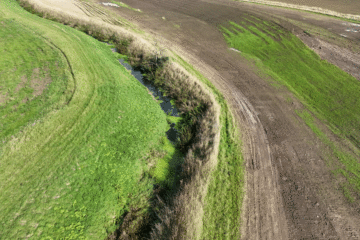
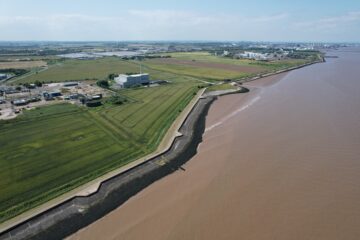
Hopgrove recently completed a drone river survey of the Foss River north of York. The Environment Agency commissioned the survey to assess the river’s flow and the condition of the river’s banks. This was part of the City of York’s Flood Alleviation Scheme. As you can see in the video the drone flew along the river at a height of 50 feet to capture detail required.
When it comes to surveying rivers, drones have a number of advantages. Cost-effective: Using a drone to survey a river is far less expensive than traditional survey methods. Hiring a helicopter or a survey boat is the traditional method of river survey.
High Resolution Survey Images and Video
Our drones, which are equipped with high-definition cameras, can capture detailed images of the river and its surroundings. This allows for a more accurate assessment of the river’s flow and riverbank condition. We can get a bird’s eye view of the river by using drones, which allows us to see the entire length and width of the river. This level of detail is critical for understanding the river’s overall health and identifying potential problems.
Our drones are also safe and efficient in surveying difficult-to-reach areas like steep river banks or fast-flowing river sections. Drones can easily navigate and capture images in these areas.
Low Cost River Surveys
Furthermore, drones can cover a large area in a short period of time. This enables a more rapid assessment of the river, which is especially important in the case of a flood relief scheme where time is of the essence. With the ability to quickly cover a large area, any necessary actions can be completed in a short period of time.
All of these benefits make drones the ideal solution for river surveys and flood mitigation schemes. Our detailed images and video provide the information needed to make educated decisions about the health and management of our rivers.
The Environment Agency was thrilled with the results of our drone survey of the Foss River. The detailed images captured by the drone enabled a more accurate assessment of the river’s flow and the condition of the river banks, which is critical for the success of the City of York’s Flood Alleviation Scheme.
Nationwide Drone River Surveys
Hopgrove Productions can provide river surveys throughout the United Kingdom. Our drone surveys are both cost-effective and yield detailed results, making them an ideal solution for any flood mitigation or river management project.
Please contact us for more information or a quotation.